National Park "Illas atlánticas de Galicia"
There is no doubt that the thinnest sand expanses, like a mirror for the sun, and the best ocean waters can be found here, colder and saltier than in inner rias.
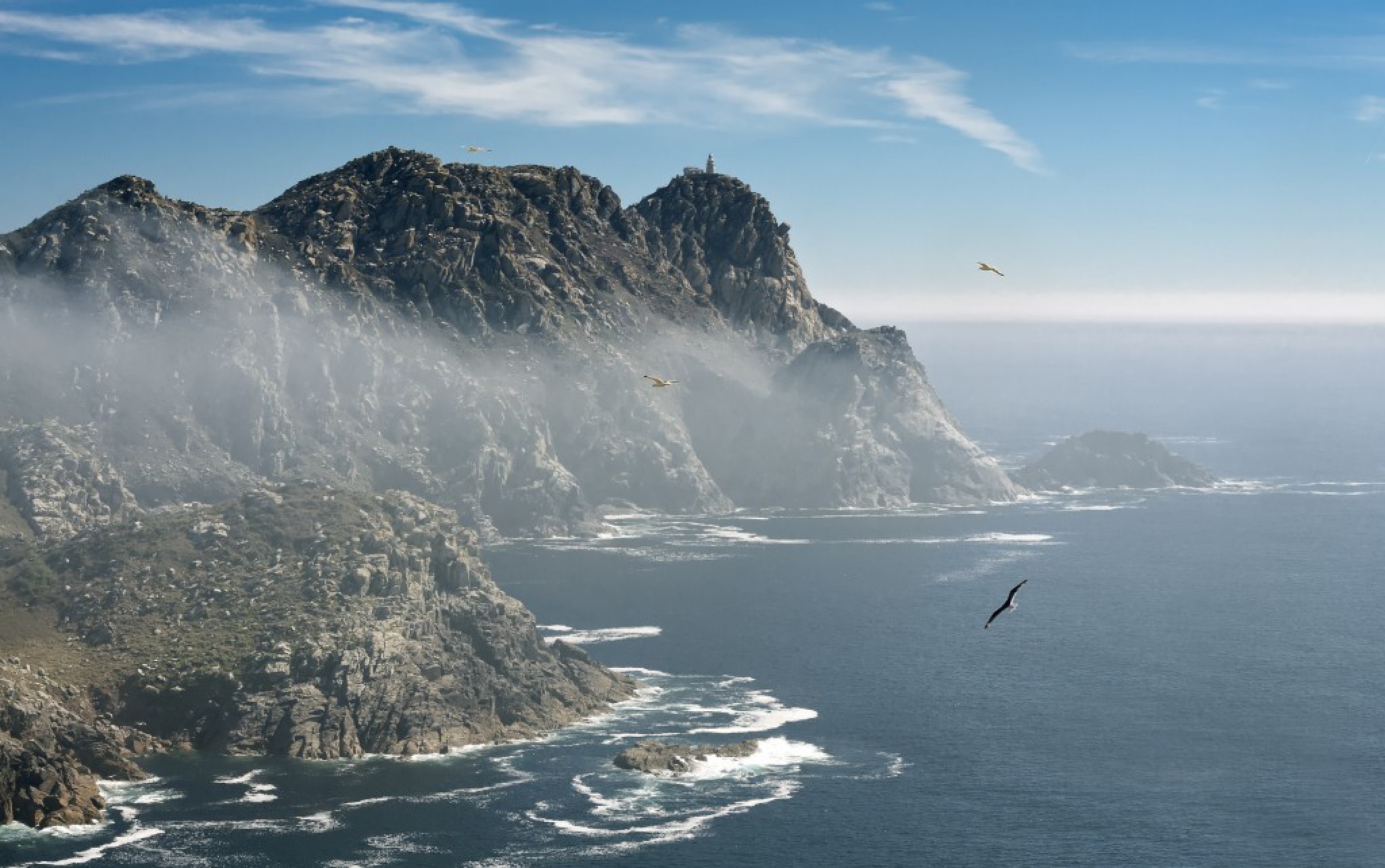
In the Cíes, you can hear seagulls scream deafeningly during the breeding season on the cliffs open to the sea. They form the largest colony around our coasts, with about 22,000 breeding pairs. From the boat that will take you there, you can see the still silhouette of three islands that often look like two. The Northern one, called Monte Agudo, joins the Illa do Medio (Middle Island), also known as Illa do Faro (The Lighthouse Island) through the sand extension on the beach of Rodas, with the Lago dos Nenos in the distance. The Illa do Sur, also called San Martiño, is separated from the others by a channel which truly deserves its name of “sea gate”. In addition, there is a group of islets connected, below sea level, to sea bottoms of rich biodiversity, with large seaweed bushes teeming with shellfish and other gastronomy products within a protected area.
Ons and Onza, its sister, close the Pontevedra ria through a coastal line that seems to have been drawn with a ruler. However, the part which is not visible from the land is extremely winding and suitable for the formation of furnas (caves) and foamedged reefs. On this ocean side, the underwater landscape consists of vertical walls whose rich life results from the outcrop of deep, nutritious waters. These characteristics are shared with the Cíes. However, at first sight, the Ons island soffer a more reduced tree vegetation on the emerged surface.
The archipelago of Sálvora, on the western end of the Arousa ria, has a high number of islets, which make navigation difficult and have caused several shipwrecks. Even if it a few private houses have been built on the main island, it has no access for tourists at present. The small islets of Vionta, Herboso and Noro are fully considered as protected areas. The only activities permitted here are research work and monitoring of its environmental values.
Inside this Arousa sea, whose biological richness is highly valued, the Cortegada island is practically a stone´s throw away from the port and promenade of Carril, in Vilagarcía de Arousa. Despite this proximity and a historically complex distribution of its properties, Cortegada and the neighbouring Malveiras bring their own natural values, such as a unique laurel grove, to the network of Natural Parks.
There are no vehicles here, and the number of visitors allowed in the Cíes every is limited to 2,200, which renders this area particularly quiet. In the two main islands, joined by a beach and a small bridge, all the paths are clearly indicated from the Rodas pier. The main routes take visitors to each of the three existing lighthouses. Combined with the two existing observatories, they make it possible to walk across the islands without entering the area which protects the cliffs and furnas from the northern end of O Cabalo to the southern end of Canabal.
Along the longest road to Monte Faro, southwards, besides the beach and the lake we can discover the A Campá observatory, located on pure rock and surrounded by the deafening cackling of seagulls. On the final section, before the zigzagging climb to the lighthouse, we can approach the pre- Roman castrexo village. Even if these areas are known as Siccas (“arid”) and are inhabited today, there are signs indicating that monks, hermits and fishermen lived here in the old times.
On the island of Ons, the routes start from the pier on the beach of Area dos Cans and the O Curro´s group of houses built around this pier. It is possible to climb to the vantage point of the lighthouse around the houses of the islanders, who traditionally made a living by selling octopus and shellfish until the mid-70s, when they started leaving the place. If you go towards the ends, you can choose to go northwards, to the solitary and beautiful Melide beach, or southwards, through several paths, all leading to Cova and Burato do Inferno, a pit-shaped furna where it is possible to hear the sea roaring in the bowels of the earth. The boat tickets that will take you to the Cíes islands indicate the day and the time of return. There is no regular transportation service to sail from one island to another, but it is possible to go on tourist cruises in order to visit the whole ecosystems of the rias, and the mussel-breeding areas in particular.
If you prefer to witness production activities, the pier and promenade of Carril offer remarkable shellfishing lessons on its clam or cockle breeding grounds. They represent the only border of the Cortegada island, which displays its thick pine grove in the foreground.